Indian Government Ignores Own Warnings in Fragile Himalayas
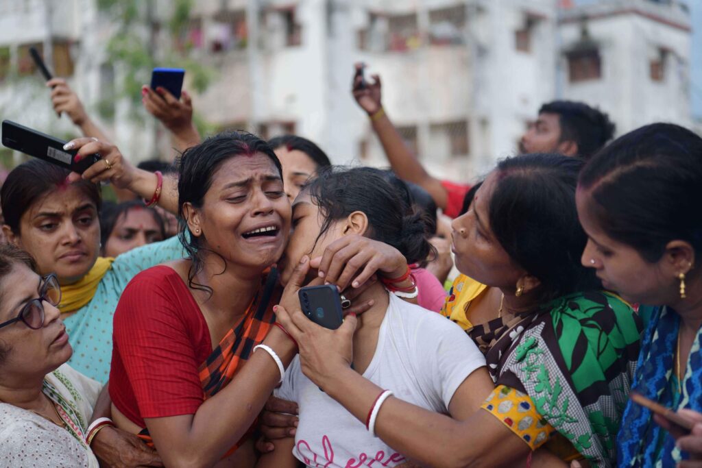
A week after a flash flood swept away pilgrims and their tents near the Hindu pilgrimage site of Amarnath at the western end of the Indian Himalayas, at least 40 people are still missing, while 16 deaths have been confirmed. Around 15,000 people had to be rescued after the disaster on 8 July. The pilgrimage resumed on the fourth day following the tragedy.
At the eastern end of the Indian Himalayas, at least 52 people were killed in a landslide on 30 June near a railway line being built to Imphal, the capital of Manipur. The line has been described by the railway ministry as its most ambitious: it involves digging 46 tunnels under the mountains, including one that is 11.55 km long, slated to become the longest in India. A substantial piece by The Hindu revealed that the Manipur Public Works Department had warned against siting the line along unstable hillsides. Railway officials have chosen to blame the disaster on slash-and-burn cultivation, while independent observers told The Hindu that railway engineers undercut the hillside to a dangerous degree.
As the fragility of the Himalayas increases with the impacts of climate change, repeated warnings are being ignored, from pilgrimages to the construction of rail lines, roads, dams and other infrastructure projects.
The widening of roads leading to four Hindu shrines in Uttarakhand – Kedarnath, Badrinath, Gangotri and Yamunotri – is a case in point. Environmentalists went to court to prevent the work. The Supreme Court set up a committee of experts. In 2020, Ravi Chopra, chair of the committee, recommended against the widening, as The Third Pole reported. The government went back to the Supreme Court to say that the army needed wide roads to move armament to the India-China border. The court then allowed the widening. The number of pilgrims on those routes – the same routes that were hit in 2013 – is many times the number of soldiers using them or heavy armaments being moved.
Amarnath: A disaster foretold
The Amarnath pilgrimage is an annual affair with repeated disasters, now made more likely by climate change. In the disaster last week, tents for pilgrims had been set up on the floodplains of Panchtarni, a confluence of five rivulets below the final ascent to the 3,880-metre-high cave shrine. The flash flood was the result of heavy rain upstream in one of the rivulets.
The extreme risk of setting up tents in floodplains was made clear by the Kedarnath flash flood in June 2013 in the central Himalayas, when at least 800 people were killed in Uttarakhand and millions affected. In that case too, tents and buses on the floodplains were swept away in a glacial lake outburst flood.
In 2021, there was another flash flood near the Amarnath shrine. There were no casualties because the pilgrimage had been suspended due to the Covid-19 pandemic.
As this year’s pilgrimage was being planned, disaster management experts speaking to each other in personal exchanges over social media, seen by The Third Pole, warned the authorities against putting tents in the floodplains. The authorities responded that there was no other space in the steep hilly area. The compromise was to site the tents as far away from the riverbed as possible and to build a two-foot-high stone wall to keep the water away in case of a flash flood. When the flood came, both measures proved inadequate. The authorities now say they did not put the tents in the floodplains, despite video evidence from pilgrims to the contrary.
Too many pilgrims despite recommended limit
One point on which the authorities are correct is that there is no space to house around 15,000 pilgrims at a time except on the floodplains. But there should not be so many pilgrims near the shrine at all. After a disaster in the area in 1996, the Indian government set up a commission to recommend how to avert a repeat. The commission, chaired by bureaucrat Nitish Sengupta, said there should be no more than 3,000-3,500 people in or around the shrine in a day.
None of these lessons have been learnt. The India Meteorological Department is now being blamed for not forecasting the heavy rainfall and the consequent flash flood despite having a dedicated website for the pilgrimage. But experts speaking to authorities in private social media group exchanges pointed out that science to forecast sudden rainfall in mountain areas does not exist yet.
There will be damage when there are flash floods. But authorities have heightened the risks by paving much of the route to the Amarnath cave, which prevents water from seeping underground. The chances of flooding with even moderate rainfall have increased.
Even now, no lessons learnt
Disaster management experts have reiterated some safety precautions for the Amarnath pilgrimage after last week’s disaster, starting with siting of tents on high ground; no pilgrim inside the cave shrine after 3 pm so that people can get to safer places by daylight; a risk assessment every 30 minutes; proper earmarking of emergency routes; and most importantly renewed assessment of the number of pilgrims that should be allowed in the area in a day.
But there is no indication that the authorities are listening, even now. There is no move to restrict the number of pilgrims.
And it is not just the authorities. It becomes very difficult to plan safety measures in the face of fatalism by most pilgrims. This year, for the first time, every pilgrim was given a radio frequency identification device (RFID). Everyone was told to wear this around their neck. But far too many pilgrims kept the device in handbags or pockets. When rescue teams used RFID locators to search for people buried under rubble after the flash flood, they kept finding the devices far from the victims. Many more lives may have been saved if all pilgrims had kept the devices around their necks.
As climate change increases the likelihood of such disasters, both the authorities and individuals need to better heed the advice and preventative measures that are available.
(Joydeep Gupta is South Asia Director of The Third Pole. Courtesy: The Third Pole. The Third Pole is a multilingual platform dedicated to promoting information and discussion about the Himalayan watershed and the rivers that originate there.)
❈ ❈ ❈
Climate Change Wreaks Havoc in Uttarakhand’s Mountainous Terrain
Seema Sharma
Indiscriminate road building and hydropower projects are increasing the vulnerability of the mountainous areas of Uttarakhand to the impact of climate change that is manifesting in the form of cloud bursts and flash floods in recent years. With every passing year, both frequency and magnitude of the disasters is getting more severe.
An example of how this is affecting the lives of people on the ground comes from Joshimath, in Uttarakhand’s Chamoli district, which witnessed a major calamity on February 7 last year due to a glacial burst which triggered floods that destroyed two hydropower projects near the Naina Devi National Park. The incident claimed 74 lives and several workers who were trapped in a tunnel near the Tapovan-Vishnugad hydel project were rescued but many bodies were found days later.
Experts believe that the construction of hydel power projects, which involves stone quarrying, blasting of mountains and digging of tunnels in the base of a mountain system could have led to the disaster.
Over a year later, the land is still unstable and local residents have been complaining of their houses developing cracks or premises and roads caving in at random places.
“The road beneath our village has caved in. The iconic statue of Gaura Devi, who led the famous Chipko Movement had to be shifted from the centre of the road. Many houses have developed wide cracks and can crumble anytime. People have no other option but to take shelter in the nearby forest area whenever it rains heavily,” said Chander Singh Rana, grandson of Gaura Devi and resident of Raini village. The village was closest to the origin of a flash flood disaster that hit the area last year.
Following last year’s flash floods, on behest of the state government, noted geologists -Saraswati Prakash Sati, Shubhra Sharma and Navin Juyal- conducted a study on the fragility of Joshimath and suggested measures to avert or mitigate catastrophic consequences for this fragile area in future.
According to the report, the very first observation by renowned geologists Heim and Gansser (1939) that the Joshimath town is situated on an old landslide deposit itself speaks about how fragile the slopes are.
However, ignoring the geological fragility of its location, the town began to grow rapidly after 1960. It was only during the late 60’s that the concern about the safety and stability of the town became an issue. The then government set up a body, named as the Mishra Committee, in 1976. The recommendations of this committee are still relevant today.
The committee recommended that as an immediate measure, there should not be any excavation activities particularly of the precariously balanced crystalline boulders. Further construction in the area should be made only after examining the stability of the site and restrictions should be placed on excavation on slopes.
Secondly, no boulders should be removed either by digging or blasting and no tree should be cut in the landslide zone. Extensive plantation work should be launched in the area particularly between Marwari and Joshimath and the cracks, which have developed on the slopes, should be sealed. Thirdly and most importantly, hanging boulders on the foothills should be provided with appropriate support and anti-erosion measures should be taken up. It was also emphasized that there should be a blanket ban on collecting constructional material from a radius of 5 km of the Joshimath town.
However none of the Mishra Committee recommendations have ever been adopted in the government’s policies or implemented on the ground.
Ravi Chopra, renowned expert on matters related to river ecology and hydro power projects said, “The way the Rishi Ganga hydro project got smashed and, Tapovan Vishnugad hydro project was severely damaged in last year’s flash flood in Joshimath, suggests no homework was done before the site selection or project viability. Besides incurring monumental economic losses, the debris of the project structures also added to the volume of the flood and magnitude of the havoc , which also led to reactivation of stabilized landslides in this region.”
The recent report by the noted geologists also mentions that Uttarakhand Himalaya is witnessing an unprecedented spree of infrastructural developmental activities. As a consequence, the precariously stabilized, debris-laden slopes become extremely sensitive towards both natural (extreme hydro-meteorological events) and anthropogenic interventions. The latter includes attempts to harness the hydropower potential of the glacial fed rivers, excavation of slopes for road networking and most importantly the unplanned proliferation of urban towns. Severity of the crises can be ascertained from the fact that during the monsoon, some region or the other in the Central Himalaya experiences a catastrophic disaster.
Geologists in the report rued the fact that least consideration is given for the slope stability and disposal of domestic wastewater. Chopra said, “The road widening work has created many new landslide zones which give trouble to local people every monsoon. Many people have been injured or died as the debris came tumbling down from the slopes, which were randomly cut and not treated as per norms after the road widening works were completed.”
In the report , geologists suggest that the road engineers must find ways to provide stability to the areas prone to subsidence by providing state-of-the-art slope treatment methods as observed at some locations along the NH-58.
Unfortunately, despite persistent efforts of officials of the Uttarakhand Climate Change Centre to make every state government department incorporate climate change concerns in their policies and allocation of budget, their advice has not made much difference.
Dr. Anjal Prakash, research Director and adjunct associate professor at the Indian School of Business (ISB), Hyderabad said, “The IPCC’s Special Report on Oceans and Cryosphere in a Changing Climate (SROCC) reports that climate change has altered the frequency and magnitude of natural hazards. We do not have the data now to give you information on what has caused the avalanche in the Joshimath but what we know, prima facie, is that this looks very much like a climate change event as the glaciers are melting due to global warming. The impact of global warming on glacial retreat is well documented. The recent assessment report called the HI-MAP report facilitated by ICIMOD has also pointed these out. The report shows that temperatures are rising in the Hindu-Kush Himalayan region and the rise in global temperature will have more impact in the Himalayan region due to elevation-dependent warming.”
He further added, “I would request the government to spend more resources in monitoring the region better so that we have more information about the change process. The result would be that we are more aware and could develop better adaptation practices.” “. Prakash was Coordinating Lead Author of the special report on Oceans and Cryosphere, 2018 and Lead Author of the 6th Assessment report of IPCC.
It is indeed the local people, who are living in disaster prone areas, who are bearing the brunt. The state government has failed to provide them any relief. The relocation or rehabilitation policy is full of loopholes. There are thousands who are still awaiting to be rehabilitated to safer places for many years.
Sharad Singh Negi, vice chairman of Uttarakhand Rural Development and Migration Commission said, “There is no need to clear the forests to create new safer places for relocation of people of disaster affected villages. The state has some 1000 villages that are lying abandoned or are thinly populated with vacant houses because of migration of the inhabitants. After improvement in infrastructure, these villages can be used for rehabilitation. “
According to Migration Commission , between the 2011 Census and 2017, 734 villages were completely vacated by their inhabitants, while in another 565, the population fell by 50 per cent in the state.
Atul Sati, Joshimath based activist said , “There are glaring loopholes in the state rehabilitation policy, which provide for compensation of Rs. 360,000 and an allocation of 100 sq ft of land to a family without adequate land for agriculture, livestock grazing etc. This is the reason, people who have been relocated to newer places have been going back to their old disaster prone native villages to take care of their agrarian land.”
(Seema Sharma is a Chandigarh based freelance journalist who writes about environment, climate change, human rights and gender issues. Courtesy: Countercurrents.org.)